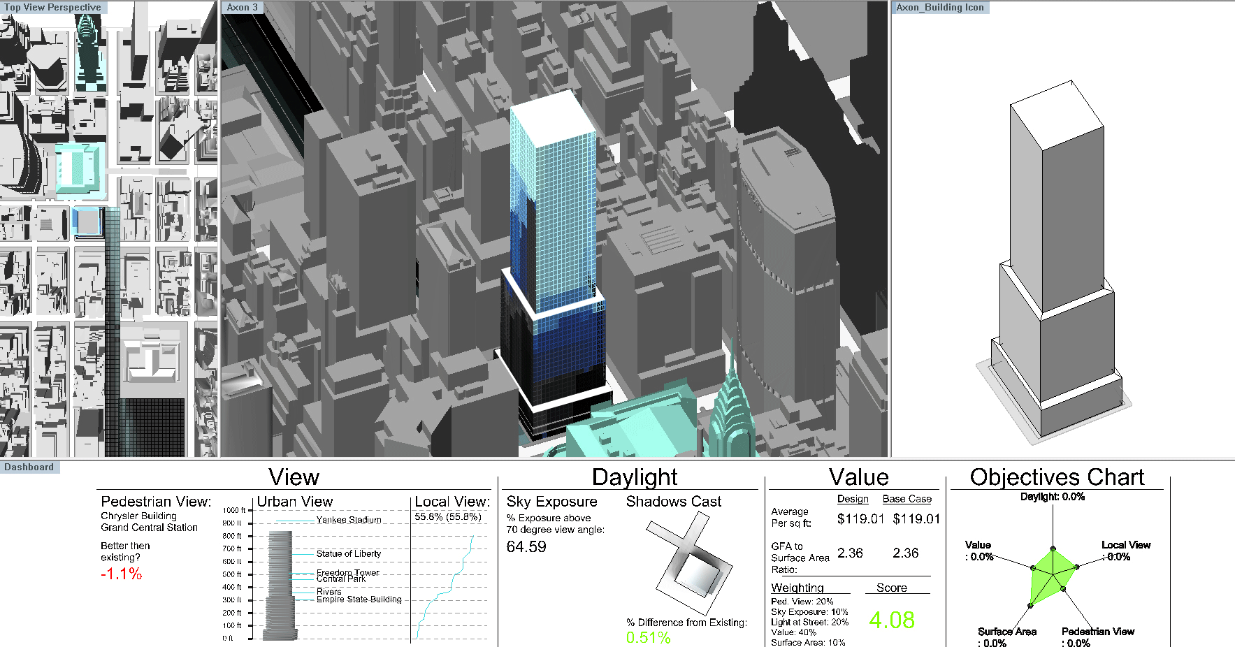
Project Approach

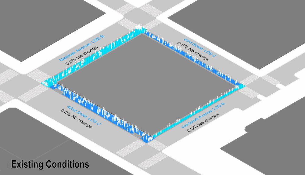
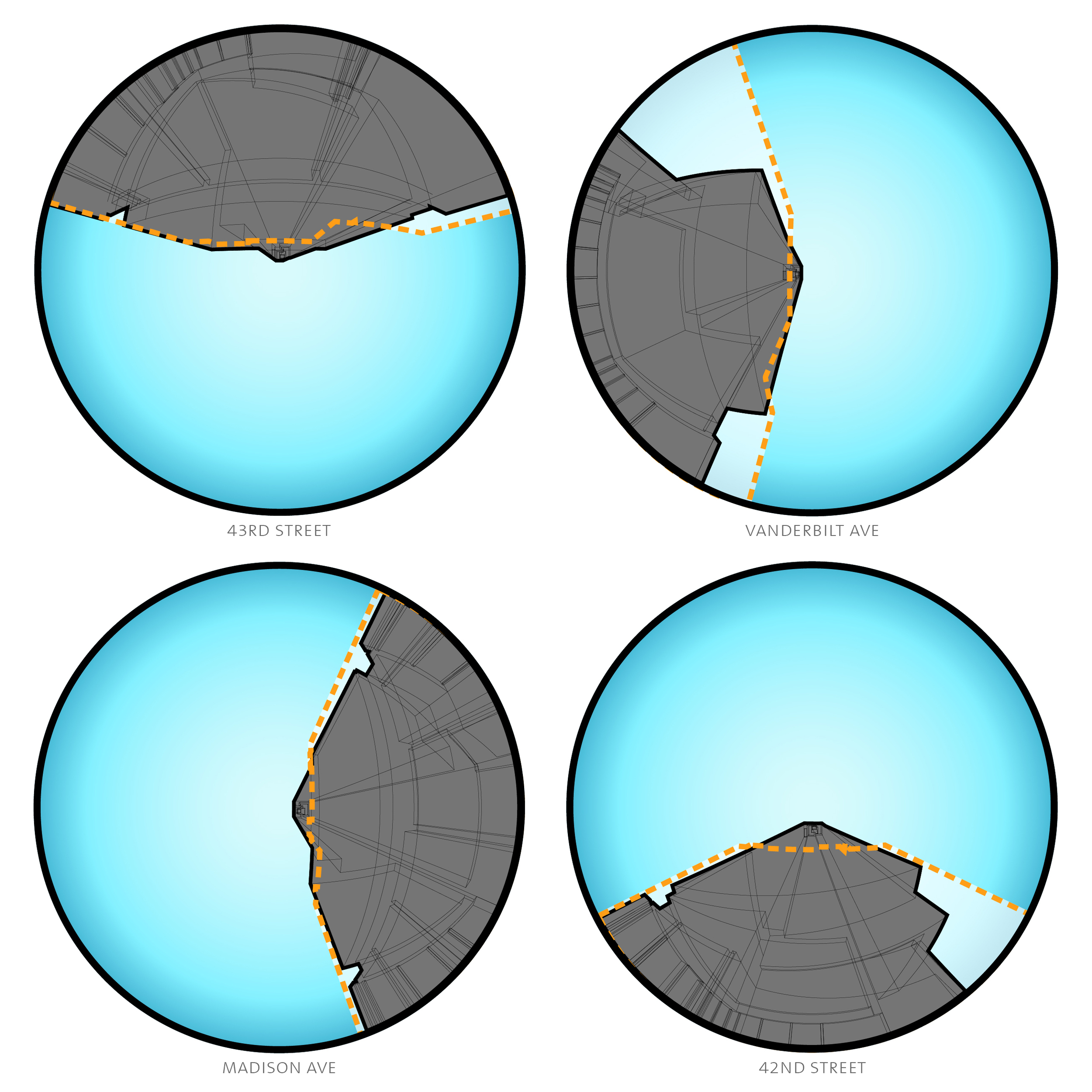
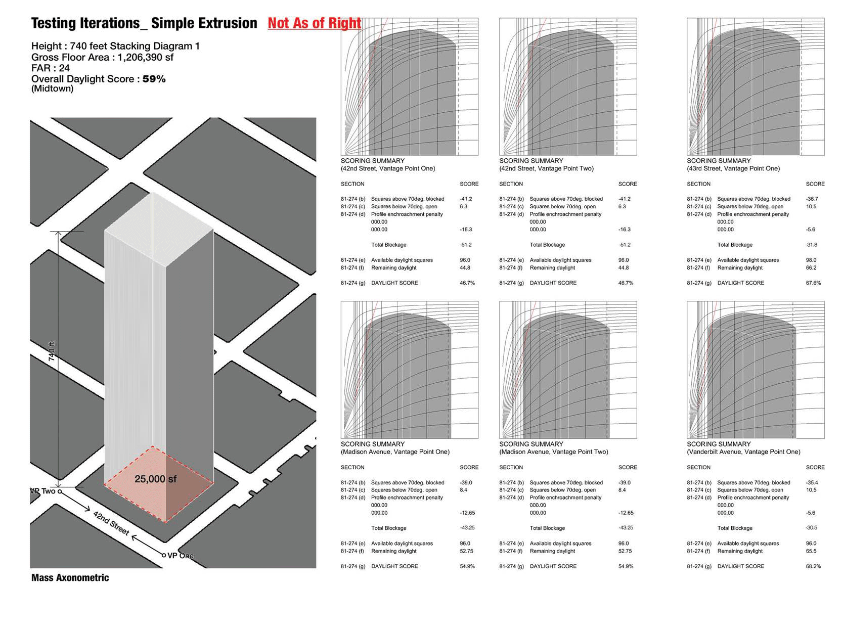
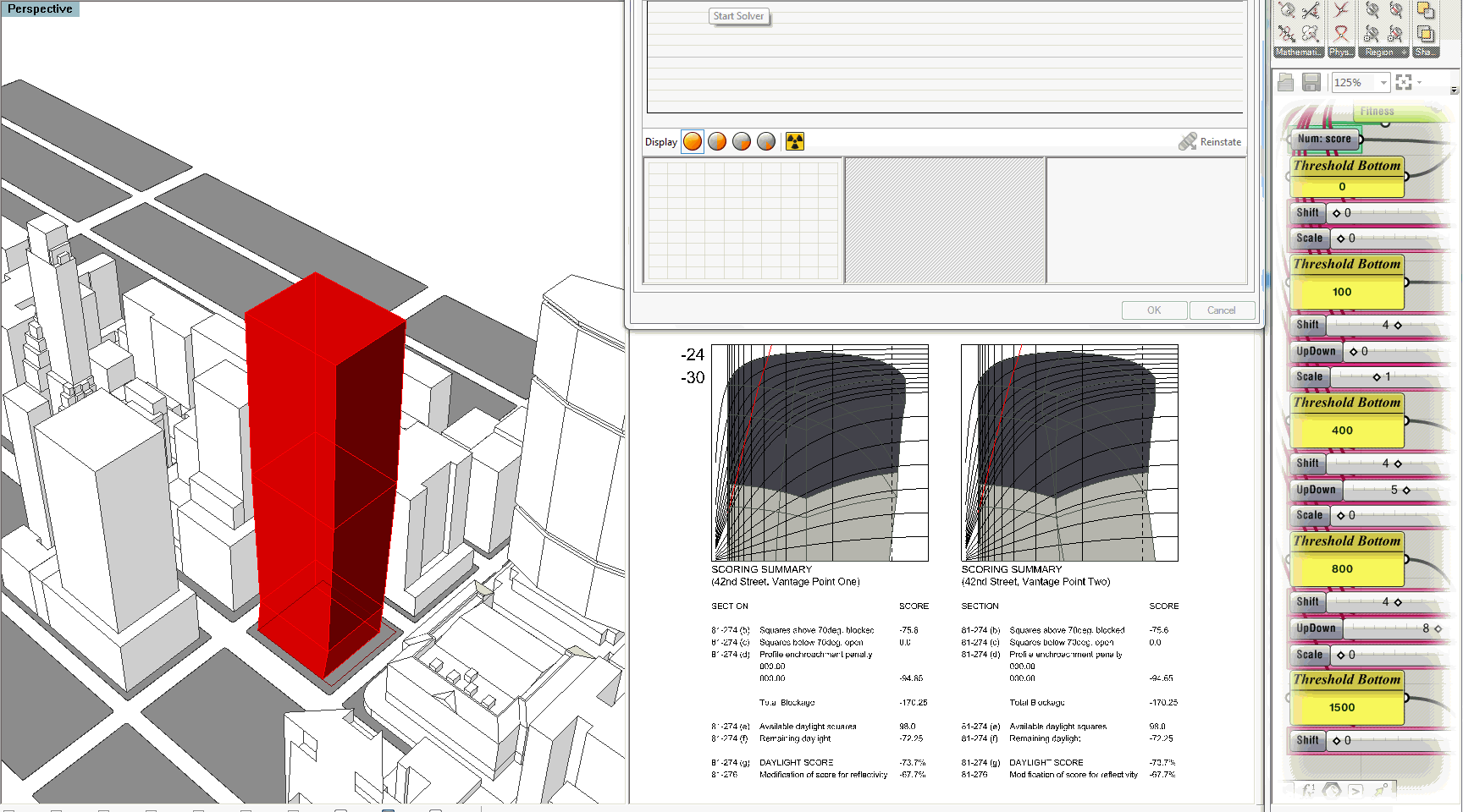
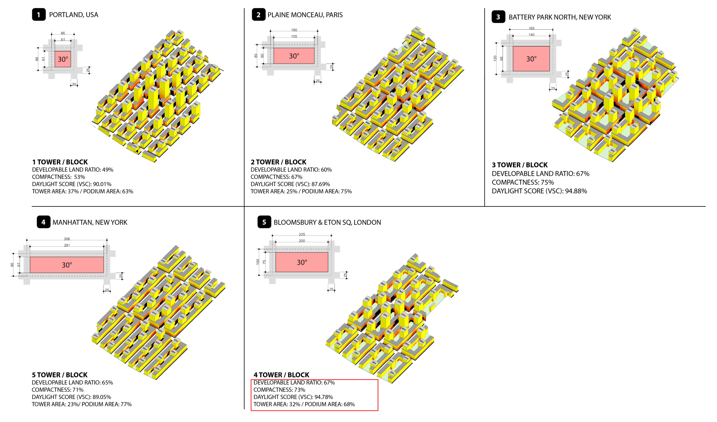
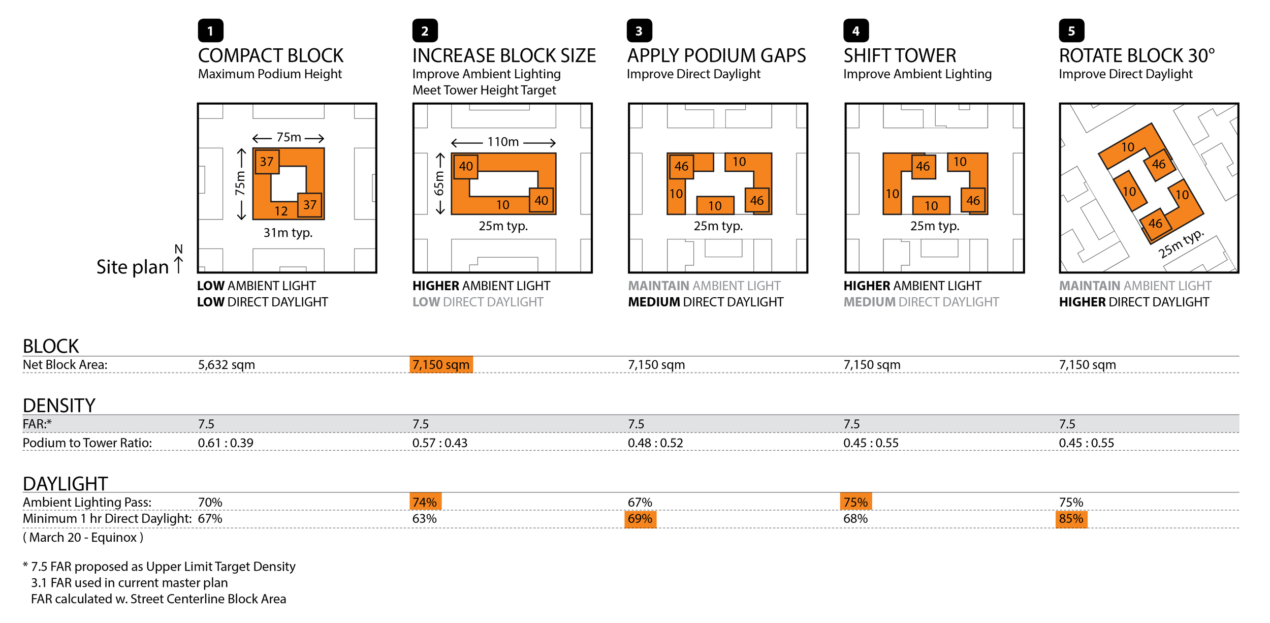
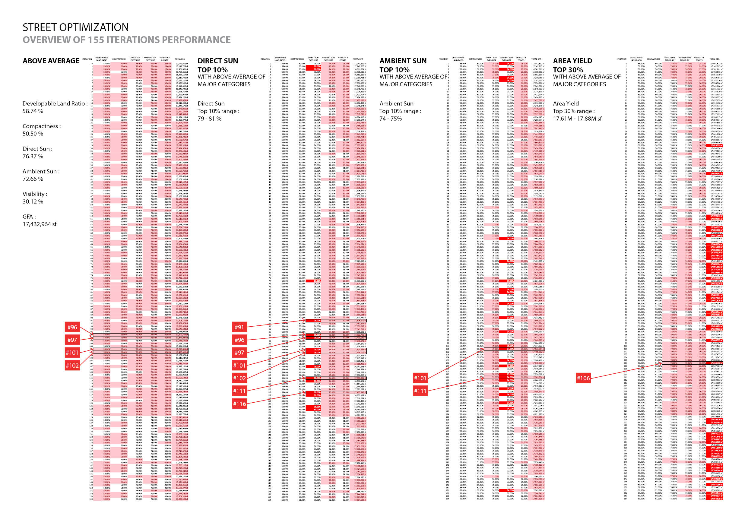
At the start of a project we work with the client to identify the key objectives that drive the design of project, such as zoning regulations, solar orientation, views to landmarks, and floor plate efficiency. We then pull from a library of custom analysis tools and integrate them into an analysis system to test and evaluate potential options for the site. This includes early site exploration to determine the best range of heights, orientations and locations for a particular site, to the refinement design schemes to the evaluation of city or community board objectives to facilitate approvals. Underlying all of this is a computational methodology (sometimes referred to as “Generative Design”) that gives us the ability to test tens of thousands of options, providing a comprehensive understanding of high performance design.

Below are three case studies that illustrate how this methodology is applied in a range of scales, contexts, and program types and is integral to our design process.

One Vanderbilt is a 1,400 foot, super tall office tower adjacent to Grand Central Terminal in the heart of Midtown Manhattan. The size and complexity of One Vanderbilt, combined with its dense urban context, made meeting various stakeholder expectations a significant challenge. KPFui created custom evaluation tools and used data analytics to reconcile competing objectives and facilitate the design of New York City’s newest icon.   Learn more about the design of One Vanderbilt on the KPF website and on the official building website.

OneVan_Objectives.jpg

Working with our client, SL Green, and the Department of City Planning, KPFui identified a set of key development objectives, including improving pedestrian flow, allowing daylight to access the street, and not obstructing views of Grand Central Terminal. We then built custom evaluation tools to measure each objective, integrating the tools into a single analysis system that allowed for real-time iteration and evaluation. Our process enabled informed decision-making and allowed the design to move forward quickly. 

Metric Dashboard comparing the performance of different massing options.

Metric Dashboard comparing the performance of different massing options.

Summary comparison of massing options

Summary comparison of massing options

Pedestrian flow animation illustrating existing conditions, impact of East Side Access and relief provided by One Vanderbilt

Pedestrian flow animation illustrating existing conditions, impact of East Side Access and relief provided by One Vanderbilt

Once the design for One Vanderbilt was made public, it became especially important to communicate its impact to the community board and the Landmarks Preservation Committee. Our models and data analysis were key to facilitating the conversation and the review process.

Publicly available data provided information regarding existing and projected pedestrian conditions, which KPFui used to construct a simulation model. The model explored the role a public plaza would have in relieving pedestrian congestion when construction on the East Side Access, a new commuter rail, was complete. Read more about the quantification of East Side Access.

One important analysis considered the impact One Vanderbilt would have on sky exposure, which is the percentage of sky visible at a given point and is a measurement of ambient daylight access. We quantified ambient daylight and compared the results against the buildings that One Vanderbilt would replace. While the tower has more than twice the floor area of existing buildings, its negative impact on sky exposure was comparable, being even slightly better, given the tapering of the design. 

Learn more about the quantification of supertalls in The Science of Supertall.

Existing Building - Sky Exposure: 72.5%

Existing Building - Sky Exposure: 72.5%

One Vanderbilt - Sky Exposure: 73%

One Vanderbilt - Sky Exposure: 73%

Locations of fish-eye perspectives

Locations of fish-eye perspectives

Given One Vanderbilt’s size, the results of the sky exposure analysis are not intuitive. How can a building that is more than twice the size actually block slightly less of the sky? The challenge with any quantitative analysis of the built environment is in illustrating the resulting metric to ensure that results are easy to understand and believe. To visualize the analysis we produced a series of 360-degree, fish-eye perspectives, taken from each side of the building. These graphics helped elected officials and the public to more fully understand the impact the building would have and illustrated that formal design decisions, carefully articulated setbacks and tapering, conceal much of the building from view at the street level. 

Concurrent to the design of One Vanderbilt, the New York City Department of City Planning was revising zoning regulations, which included increasing the allowable density, or Floor Area Ratio (FAR), for portions of East Midtown. Existing regulations to control the bulk of a building were originally design to accommodate a maximum of 15 FAR, whereas the proposed zoning changes would increase FAR to as much as 24 for certain sites.

KPFui assisted the city in studying the rezoning issue, developing digital versions of bulk regulations for Midtown and testing thousands of massing options under the proposed 24 FAR density. It was determined that commercially viable 24 FAR office buildings that complied with current bulk regulations were impossible, necessitating the revision of zoning regulations. KPFui worked with the city to develop and test a series of revisions to bulk regulations that would achieve the desired density while minimizing negative impacts.

Testing of various 24 FAR options under current midtown bulk regulations, 81-27 Daylight Evaluation. The bulk regulations use a modified version of the Waldram Diagram, first implemented in London, as a way to quantify the percentage of sky tha…

Testing of various 24 FAR options under current midtown bulk regulations, 81-27 Daylight Evaluation. The bulk regulations use a modified version of the Waldram Diagram, first implemented in London, as a way to quantify the percentage of sky that a building blocks from specified vantage points.

Optimization searching for viable 24 FAR massings that comply with bulk regulations.

Optimization searching for viable 24 FAR massings that comply with bulk regulations.

While the East Midtown rezoning, as proposed under the Bloomberg administration, was not adopted, it is being revised and reevaluated under the city’s current leadership. KPFui, in collaboration with Jesse Keenan at the Harvard Graduate School of Design, is again assisting the rezoning process, helping to shape the future of New York City. 

London is currently in a housing crisis; demand is far outpacing supply resulting in increasingly unaffordable housing. To help meet the housing demand KPFui developed an ideal block typology and master planning principles to achieve higher densities  while balancing access to daylight.

Because a higher density than is typical throughout London is necessary, it is not possible to rely on existing block typologies to meet demand, a new typology is needed. We started by analyzing historic block typologies, most specifically looking at density, or Floor Area Ratio (FAR.) We found that the block typologies that Londoners were familiar with are typically between 1 - 3 FAR , while our target density to meet demand is 4 - 6 FAR. Next, we increased the heights of the historic block typologies to 6 FAR, the upper end of the target density, and analyzed them for daylight access to residential units (Vertical Sky Component,) sky exposure on public spaces (ambient daylight,) and site coverage (efficiency.) What we found was that all the typologies, except for the Barbican, performed poorly when taken to this density, while the block typology we were proposing, split courtyard building with towers, performed much better.

Timeline of london block typologies

Timeline of london block typologies

London block typologies at 6 FAR.

London block typologies at 6 FAR.

In the design of new neighborhood understanding the physical capacity of the site is crucial to being able to maximize density while creating an attractive, vibrant and livable area. Here we tested various block sizes deployed across a hypothetical London site, all developed to the target floor area. We were able to determine the range of block sizes that performed best. In the end, the dimensions of a London block, Bloomsbury, was best suited to the site and block typology and variations on it were developed in the design of the plan. 

Analysis of block size capacity relative to daylight access.

Analysis of block size capacity relative to daylight access.

Orientation tests to maximize residential daylight.

Orientation tests to maximize residential daylight.

Concurrent to the urban scale block study, we worked to optimize the performance of the proposed block typology for a number of criteria (outlined below,) but most importantly,  to maximize density while maintaining residential and public space daylight levels. 

Performance criteria

Performance criteria

Once the performance criteria was defined we ran a series of optimizations, testing tens-of-thousands of block configurations, to determine not the single optimal solution, but rather, a range of high performing block configurations that allowed for flexibility in the design process. That range was then turned into a set of rules-of-thumb to be followed within the design of a master plan. 

Testing of tens-of-thousands of options to determine a range of high performing block configurations.

Testing of tens-of-thousands of options to determine a range of high performing block configurations.

Rules of thumb developed from top performing configurations

Rules of thumb developed from top performing configurations

Transformation from dumb block to smart block.

Transformation from dumb block to smart block.

Overview of ideal block configuration.

Overview of ideal block configuration.

Next we applied results of the optimal block study to a hypothetical site and varied the street grid to test out a range of street configurations to demonstrate how master plan can be calibrated within a specific context. 

Iteration of street grid

Iteration of street grid

Performance comparison of 155 iterations. Pink highlight indicates above average performance specific metric

Performance comparison of 155 iterations. Pink highlight indicates above average performance specific metric

In the end, the application of data rich models and analysis tools helped to develop block and master plan typology can help meet London housing demand while maintaining proper daylight access to  residential units and streets. Ultimately, the characteristics that will make  a lively and well functioning neighborhood will come from the architectural and urban design, but grounded on rigorous, data driven analysis. 

Shanghai is urbanizing at an incredible rate, with 11 times the floor area constructed from 2000 to 2014 as was constructed between 1978 and 2000. Shanghai has building and planning codes to manage the impact of growth and new density. Most typically this manifest as maximum heights, building separation, and residential daylight access. This regulations presented a challenge in the design of a new master plan, Crystal Plaza.

The master plan called for 3.2 million sq ft of office, residential, and retail to be design over five blocks being developed by . The constraints set by the building and planning regulations made it very difficult to fit the target area within the site. KPFui developed digital versions of the various city regulations that allowed for the iteration of tens-of-thousands of massing options to determine the range of master plan configurations that complied with the regulations:

  • Maximum Building Height: specified per block
  • Residential Daylight: bedrooms and living rooms are required to get at least one hour of direct daylight on the winter solstice
  • Building separation: dimensions determined based on use (office vs residential,) building height and orientation.

The requirements were integrated into a single analysis model:

Diagram of analysis system

Diagram of analysis system

Residential daylight access requirements. Window orientation and time range of acceptable daylight (left.) Visualization of passing and failing surfaces (right.)

Residential daylight access requirements. Window orientation and time range of acceptable daylight (left.) Visualization of passing and failing surfaces (right.)

Diagram of building separation requirements for residential and office.

Diagram of building separation requirements for residential and office.

To determine a range of massing configurations that would comply with regulations we developed a massing model that could very within designed set of rules . For residential buildings we tested configurations with 8 & 10 towers and allowed each tower to vary based on the number units per floor from a point tower to a slab tower, to rotate +-30 degrees, and to change location. For office towers we allowed the floor plate size to vary, 360 degree rotation, and location change. 

Residential massing range.

Residential massing range.

Office massing range.

Office massing range.

We then ran a series of optimizations to test all possible configurations of the above massing variations in search of options that passed all of the city regulations.

In order to understand the range of performance, ie where we could place buildings that would comply with city regulations, KPFui generated a series of diagrams to illustrate the trends of height, location and orientation. Finally, these trends were distilled into a diagram that could be followed in the design of the masterplan. For some buildings, in particular the office buildings on the north two blocks, there was a high range of freedom in massing, but for others, namely the residential buildings to the south, the location was fixed.

Range of massing options complying with city regulations

Range of massing options complying with city regulations

Diagram of location, rotation, and height trends.

Diagram of location, rotation, and height trends.

Without the aid of these tools and methodology the process for determining compliance with city regulations can take months and testing individual designs can be time consuming. Instead it only took us two weeks to determine the range of complying options and set us up to be able to quick analyze future design options.